When planning any form of construction, infrastructure or development project, the ground beneath your feet is both your foundation and your greatest unknown. What appears stable on the surface can hide complexities such as weak soils, corrosive conditions, buried voids or materials that are difficult or costly to excavate. Understanding these risks early is vital to avoiding delays, cost overruns and safety hazards. This is where the British Geological Survey (BGS) Civils plays a critical role, ss discussed in our video conversation which you’ll find links for throughout this article. This dataset is deliberately focused on the uppermost three meters of the subsurface [01:55]. This is the most crucial zone, where nearly all foundations, pipelines and general infrastructure services are laid and it is the depth you are most likely to dig into.
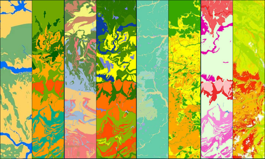
The British Geological Survey, has long been a trusted source of geological mapping and subsurface data. However, in recent years its focus has expanded beyond academic geology to include practical datasets designed specifically for ground engineering and construction. One of its most valuable contributions in this space is BGS Civils, a specialised dataset built to bridge the gap between geology and engineering. Rather than describing what the ground is, in terms of rock names and stratigraphy, BGS Civils translates that knowledge into what the ground does from an engineering perspective.
This traditional geological information has been turned into an accessible format for project planning, design and risk assessment. It consolidates decades of borehole records, laboratory analyses and field studies into a national dataset that summarises the engineering behaviour of the subsurface. Furthermore, we have then presented this data in an easily accessible format, ready to select as an area on the CentremapsLive interface, alongside pre-development essentials such as utility searches, flood risk assessments and boundary data. Convenient to order and ready to use in your GIS or CAD system as part of your project analysis.
The dataset captures a range of critical engineering characteristics that directly influence construction feasibility and cost. For example, it evaluates the strength of geological materials, offering a practical sense of how firm or weak the ground is likely to be. This early indicator helps engineers anticipate potential excavation difficulties or foundation issues[02:31] . It also maps discontinuities, such as fractures, bedding planes or fissures, which affect how easily the ground can be broken apart or how stable it will remain during and after excavation [02:54].[03:12], an important consideration for budgeting and equipment selection, as it determines whether a site can be excavated using standard machinery or whether more intensive methods are required.
Equally important is the bulking volume property, which helps project teams estimate how much excavated material will expand once removed from the ground [03:20]. This simple but powerful piece of information has a direct bearing on waste management and transport logistics. Closely linked is the engineered fill characteristic, which provides an indication of whether excavated materials can be reused on-site, for example in embankments or backfill, or whether they must be removed and replaced at additional cost.
Chemical and environmental ground risks are also addressed through two further parameters. The corrosivity layer identifies soils that may degrade ferrous metals, such as pipelines, steel piles or reinforcement bars, allowing engineers to select suitable protective materials or coatings before installation[03:52]. The sulfate and sulfide potential layer highlights where reactive minerals in the ground may attack concrete and cementitious materials, causing long-term deterioration if not properly mitigated [04:04]. This is a critical insight for foundation design and material specification, as failure to anticipate such chemical reactions can lead to costly remediation later in a structure’s life.
A further layer, the foundation conditions summary, integrates the physical and chemical factors into a general assessment of the ground’s suitability for supporting structures [05:47]. Together, these parameters give engineers a clear overview of the likely challenges at a site and allow them to make informed decisions during feasibility and early design. The true strength of BGS Civils lies in how these interlinked layers create a multi-dimensional understanding of the ground, revealing not just what lies beneath but how it behaves and how it might respond to engineering intervention.
With the national shift toward electric vehicles (EVs), new energy generation and smarter infrastructure, the ground's ability to conduct electricity is more important than ever. Resistivity data, which is a function of clay content, moisture, and temperature [08:16], is essential for people planning to install transformers, new cables and earthing electrical systems[04:46]. Simply put, it helps you understand how current flows through the ground and is a dedicated layer alongside the other Civils data.
Integrating BGS Civils into a project’s early planning brings tangible advantages. At the feasibility stage, the data acts as a cost-effective “first look” highlighting areas that may warrant closer investigation or special consideration. When preparing tenders, contractors can use the information to refine their pricing and construction methods, reducing the likelihood of unexpected costs later on. Designers can also use Civils data to adapt plans at an early stage, for example by adjusting building layouts, foundation types or trench alignments to suit the local ground conditions. BGS Civils is ultimately a strategic tool designed for early stage decision making. As you’ll hear in our video, it's the kind of dataset you look at "over a cup of coffee first thing on a Monday morning" when you need to decide whether to bid for a job or work in a specific area [09:08].
Of course, while BGS Civils is an incredibly powerful tool, it is not a replacement for site-specific geotechnical investigations. It provides a predictive model based on known geological units, meaning that local anomalies or man-made ground features may still require further testing and validation. Best practice is to use Civils as part of a layered risk management strategy, first to screen and prioritise areas for investigation and later to cross-check and supplement the results of physical sampling. It provides an efficient, engineering-focused answer to the question "Can I dig this site, move this material around and is there anything I need to be aware of?" [06:07]. The ground's geology should never stop a project, but using BGS Civils ensures you are fully aware of advantageous and less advantageous areas, allowing you to proactively factor in necessary changes and ultimately control your installation costs [08:49].
Ultimately, BGS Civils represents a significant step forward in proactive ground risk management. By translating decades of geological science into usable engineering intelligence, it allows decision-makers to spot problems before they become costly surprises. In an era when the pace and complexity of development continue to accelerate, having a reliable “early warning system” for what lies beneath the surface is invaluable. Whether used to guide a feasibility study, optimise a foundation design or reduce tender uncertainty, BGS Civils enables teams to make smarter, safer and more sustainable choices from day one.
Ready to leverage the power of BGS Civils in your next project? Don't waste time wrestling with raw data. Connect with CentremapsLive to order your BGS Civils datasets. CentremapsLive delivers the data in a structured, user-friendly format, ready for immediate integration into your CAD or GIS software, ensuring you have the critical engineering intelligence you need.
Video Source: CentremapsLive Professional Discussion; BGS Civils (https://www.youtube.com/watch?v=PApJXPgM23A)
Connect to CentremapsLive and Order BGS Civils Data Today!
Hidden Beneath the Surface: BGS Data for Ground Risk Assessment

| E | info@centremaps.co.uk |
|---|---|
| W | Visit Centremaps Limited's website |
| Open Space, Leigh Sinton Road, Upper Interfields, Malvern, WR14 1UT |
Products by this Company


